The Blue Marble, a photograph of the planet Earth made on 7 December 1972 by the crew of the Apollo 17 spacecraft.
The world is the totality of entities, the whole of reality, or everything that exists. The nature of the world has been conceptualized differently in different fields. Some conceptions see the world as unique, while others talk of a "plurality of worlds". Some treat the world as one simple object, while others analyze the world as a complex made up of parts.
In scientific cosmology, the world or universe is commonly defined as "the totality of all space and time; all that is, has been, and will be". Theories of modality talk of possible worlds as complete and consistent ways how things could have been. Phenomenology, starting from the horizon of co-given objects present in the periphery of every experience, defines the world as the biggest horizon, or the "horizon of all horizons". In philosophy of mind, the world is contrasted with the mind as that which is represented by the mind.
Theology conceptualizes the world in relation to God, for example, as God's creation, as identical to God, or as the two being interdependent. In religions, there is a tendency to downgrade the material or sensory world in favor of a spiritual world to be sought through religious practice. A comprehensive representation of the world and our place in it, as is found in religions, is known as a worldview. Cosmogony is the field that studies the origin or creation of the world, while eschatology refers to the science or doctrine of the last things or of the end of the world.
In various contexts, the term "world" takes a more restricted meaning associated, for example, with the Earth and all life on it, with humanity as a whole, or with an international or intercontinental scope. In this sense, world history refers to the history of humanity as a whole, and world politics is the discipline of political science studying issues that transcend nations and continents. Other examples include terms such as "world religion", "world language", "world government", "world war", "world population", "world economy", or "world championship". (Full article...)
The association shares the World Bank's mission of reducing poverty and aims to provide affordable development financing to countries whose credit risk is so prohibitive that they cannot afford to borrow commercially or from the Bank's other programs. The IDA's stated aim is to assist the poorest nations in growing more quickly, equitably, and sustainably to reduce poverty. The IDA is the single largest provider of funds to economic and human development projects in the world's poorest nations. From 2000 to 2010, it financed projects which recruited and trained 3 million teachers, immunized 310 million children, funded $792 million in loans to 120,000 small and medium enterprises, built or restored 118,000 kilometers of paved roads, built or restored 1,600 bridges, and expanded access to improved water to 113 million people and improved sanitation facilities to 5.8 million people. The IDA has issued a total US$238 billion in loans and grants since its launch in 1960. Thirty-six of the association's borrowing countries have graduated from their eligibility for its concessional lending. However, nine of these countries have relapsed and have not re-graduated. (Full article...)
The Central Bureau of the Map of the World was established in London. After the Second World War, UNESCO took over the project. By 1953, 400 sheets had been produced. The completed sheets became outdated before the project had produced a full set of maps, and by the 1960s was being dismissed as being of no practical use. The project was no longer monitored by the 1990s. (Full article...)
UNFCCC negotiations are conducted within two subsidiary bodies, the Ad Hoc Working Group on Long-term Cooperative Action under the Convention (AWG-LCA) and the Ad Hoc Working Group on Further Commitments for Annex I Parties under the Kyoto Protocol (AWG-KP) and were expected to culminate in the United Nations Climate Change Conference taking place in December 2009 in Copenhagen (COP-15); negotiations are supported by a number of external processes, including the G8 process, a number of regional meetings and the Major Economies Forum on Energy and Climate that was launched by US President Barack Obama in March 2009. High level talks were held at the meeting of the G8+5 Climate Change Dialogue in February 2007 and at a number of subsequent G8 meetings, most recently leading to the adoption of the G8 leaders declaration "Responsible Leadership for a Sustainable Future" during the G8 summit in L´Aquila, Italy, in July 2009. (Full article...)
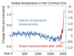
Series of reliable temperature measurements in some regions began in the 1850—1880 time frame (this is called the instrumental temperature record). The longest-running temperature record is the Central England temperature data series, which starts in 1659. The longest-running quasi-global records start in 1850. For temperature measurements in the upper atmosphere a variety of methods can be used. This includes radiosondes launched using weather balloons, a variety of satellites, and aircraft. Satellites can monitor temperatures in the upper atmosphere but are not commonly used to measure temperature change at the surface. Ocean temperatures at different depths are measured to add to global surface temperature datasets. This data is also used to calculate the ocean heat content. (Full article...)
Image 5
World government is the concept of a single political authority with jurisdiction over all of Earth and humanity. It is conceived in a variety of forms, from tyrannical to democratic, which reflects its wide array of proponents and detractors.
A world government with executive, legislative, and judicial functions and an administrative apparatus has never existed. The inception of the United Nations (UN) in the mid-20th century remains the closest approximation to a world government, as it is by far the largest and most powerful international institution. The UN is mostly limited to an advisory role, with the stated purpose of fostering cooperation between existing national governments, rather than exerting authority over them. Nevertheless, the organization is commonly viewed as either a model for, or preliminary step towards, a global government. (Full article...)
Image 6
Second preliminary session of the World Summit Information Society, plenary meeting, 18–25 February 2005, UN building, Geneva, Switzerland. The World Summit on the Information Society (WSIS) was a two-phase United Nations-sponsored summit on information, communication and, in broad terms, the information society that took place in 2003 in Geneva and in 2005 in Tunis. WSIS Forums have taken place periodically since then. One of the Summit's chief aims is to bridge the global digital divide separating rich countries from poor countries by increasing internet accessibility in the developing world. The conferences established 17 May as World Information Society Day.
The WSIS+10 Process marked the ten-year milestone since the 2005 Summit. In 2015, the stocktaking process culminated with a High-Level meeting of the UN General Assembly on 15 and 16 December in New York. The United Nations General Assembly will conclude the WSIS+20 review in December 2025.[needs update] (Full article...)
The Kyoto Protocol implemented the objective of the UNFCCC to reduce the onset of global warming by reducing greenhouse gas concentrations in the atmosphere to "a level that would prevent dangerous anthropogenic interference with the climate system" (Article 2). The Kyoto Protocol applied to the seven greenhouse gases listed in Annex A: carbon dioxide (CO2), methane (CH4), nitrous oxide (N2O), hydrofluorocarbons (HFCs), perfluorocarbons (PFCs), sulfur hexafluoride (SF6), nitrogen trifluoride (NF3). Nitrogen trifluoride was added for the second compliance period during the Doha Round. (Full article...)
Image 5Geologic map of North America, color-coded by age. From most recent to oldest, age is indicated by yellow, green, blue, and red. The reds and pinks indicate rock from the Archean.
Image 6Artist's impression of the enormous collision that probably formed the Moon (from History of Earth)
Image 10An animation of the changing density of productive vegetation on land (low in brown; heavy in dark green) and phytoplankton at the ocean surface (low in purple; high in yellow) (from Earth)
Image 13Exaggerated illustration of Earth's elliptical orbit around the Sun, marking that the orbital extreme points (apoapsis and periapsis) are not the same as the four seasonal extreme points, the equinox and solstice (from Earth)
Image 14Artist's conception of Hadean Eon Earth, when it was much hotter and inhospitable to all forms of life. (from History of Earth)
Image 15An artist's impression of ice age Earth at glacial maximum. (from History of Earth)
Image 19Earth's Western Hemisphere showing topography relative to Earth's center instead of to mean sea level, as in common topographic maps (from Earth)
Image 20An impression of the Archean, the eon after Earth's formation, featuring round stromatolites, which are early oxygen-producing forms of life from billions of years ago. After the Late Heavy Bombardment, Earth's crust had cooled, its water-rich barren surface is marked by continents and volcanoes, with the Moon still orbiting Earth half as far as it is today, appearing 2.8 times larger and producing strong tides. (from Earth)
Image 30Angkor Wat temple complex, Cambodia, early 12th century
Image 31A view of Earth with its global ocean and cloud cover, which dominate Earth's surface and hydrosphere; at Earth's polar regions, its hydrosphere forms larger areas of ice cover. (from Earth)
Image 43Change in average surface air temperature and drivers for that change. Human activity has caused increased temperatures, with natural forces adding some variability. (from Earth)
Image 46The replicator in virtually all known life is deoxyribonucleic acid. DNA is far more complex than the original replicator and its replication systems are highly elaborate. (from History of Earth)
Image 55A map of heat flow from Earth's interior to the surface of Earth's crust, mostly along the oceanic ridges (from Earth)
Image 56Artist's impression of a Hadean landscape with the relatively newly formed Moon still looming closely over Earth and both bodies sustaining strong volcanism. (from History of Earth)
Image 58Artist's impression of Earth during the later Archean, the largely cooled planetary crust and water-rich barren surface, marked by volcanoes and continents, features already roundmicrobialites. The Moon, still orbiting Earth much closer than today and still dominating Earth's sky, produced strong tides. (from History of Earth)
Image 60Japanese depiction of a Portuguese carrack, a result of globalizing maritime trade
Image 61A schematic view of Earth's magnetosphere with solar wind flowing from left to right (from Earth)
Image 62Tiktaalik, a fish with limb-like fins and a predecessor of tetrapods. Reconstruction from fossils about 375 million years old. (from History of Earth)
Image 63Earth's history with time-spans of the eons to scale. Ma means "million years ago", Ga means "billion years ago". (from History of Earth)
Image 6513th-century French historiated initial with the three classes of medieval society: those who prayed (the clergy), those who fought (the knights), and those who worked (the peasantry)
Image 67Portrait of Alfraganus in the Compilatio astronomica, 1493. Islamic astronomers began just before the 9th century to collect and translate Indian, Persian and Greek astronomical texts, adding their own astronomy and enabling later, particularly European astronomy to build on. Symbolic for the post-classical period, a period of an increasing trans-regional literary culture, particularly in the sciences, spreading and building on methods of science. (from Human history)
Image 70Earth's night-side upper atmosphere appearing from the bottom as bands of afterglow illuminating the troposphere in orange with silhouettes of clouds, and the stratosphere in white and blue. Next the mesosphere (pink area) extends to the orange and faintly green line of the lowest airglow, at about one hundred kilometers at the edge of space and the lower edge of the thermosphere (invisible). Continuing with green and red bands of aurorae stretching over several hundred kilometers. (from Earth)
Image 76Trilobites first appeared during the Cambrian period and were among the most widespread and diverse groups of Paleozoic organisms. (from History of Earth)
Image 85Pangaea was a supercontinent that existed from about 300 to 180 Ma. The outlines of the modern continents and other landmasses are indicated on this map. (from History of Earth)
Delhi, officially the National Capital Territory (NCT) of Delhi, is a megacity and a union territory of India containing New Delhi, the capital of India. Straddling the Yamuna river, but spread chiefly to the west, or beyond its right bank, Delhi shares borders with the state of Uttar Pradesh in the east and with the state of Haryana in the remaining directions. Delhi became a union territory on 1 November 1956 and the NCT in 1995. The NCT covers an area of 1,484 square kilometres (573 sq mi). According to the 2011 census, Delhi's city proper population was over 11 million, while the NCT's population was about 16.8 million.
The topography of the medieval fort Purana Qila on the banks of the river Yamuna matches the literary description of the citadel Indraprastha in the Sanskrit epic Mahabharata; however, excavations in the area have revealed no signs of an ancient built environment.
From the early 13th century until the mid-19th century, Delhi was the capital of two major empires, the Delhi Sultanate and the Mughal Empire, which covered large parts of South Asia. All three UNESCO World Heritage Sites in the city, the Qutub Minar, Humayun's Tomb, and the Red Fort, belong to this period. Delhi was the early centre of Sufism and Qawwali music. The names of Nizamuddin Auliya and Amir Khusrau are prominently associated with it. The Khariboli dialect of Delhi was part of a linguistic development that gave rise to the literature of Urdu and later Modern Standard Hindi. Major Urdu poets from Delhi include Mir Taqi Mir and Mirza Ghalib. Delhi was a notable centre of the Indian Rebellion of 1857. In 1911, New Delhi, a southern region within Delhi, became the capital of the British Indian Empire. During the Partition of India in 1947, Delhi was transformed from a Mughal city to a Punjabi one, losing two-thirds of its Muslim residents, in part due to pressures from arriving Hindu and Sikh refugees from western Punjab.
After independence in 1947, New Delhi continued as the capital of the Dominion of India, and after 1950 of the Republic of India. (Full article...)
... that self-help author Beth Kempton held positions at both the 2002 FIFA World Cup in Tokyo and the 2012 Summer Olympics in London?
... that the FogCam is believed to be the world's longest-running public webcam?
... that Indonesian radio presenters Muhammad Farhan and Indy Barends co-hosted a 32-hour nonstop radio show in 2001, setting a national record which they held until 2019?
... that during World War II, pilot G. E. Clements was removed from training for secret missions associated with the Manhattan Project when senior officers realized she was a woman?
Kenya's geography, climate and population vary widely. In western Rift Valley counties, the landscape includes cold, snow-capped mountaintops (such as Batian, Nelion, and Point Lenana on Mount Kenya) with vast surrounding forests, wildlife, and fertile agricultural regions in temperate climates. In other areas there are dry, arid, and semi-arid climates, as well as absolute deserts (such as the Chalbi Desert and Nyiri Desert). (Full article...)
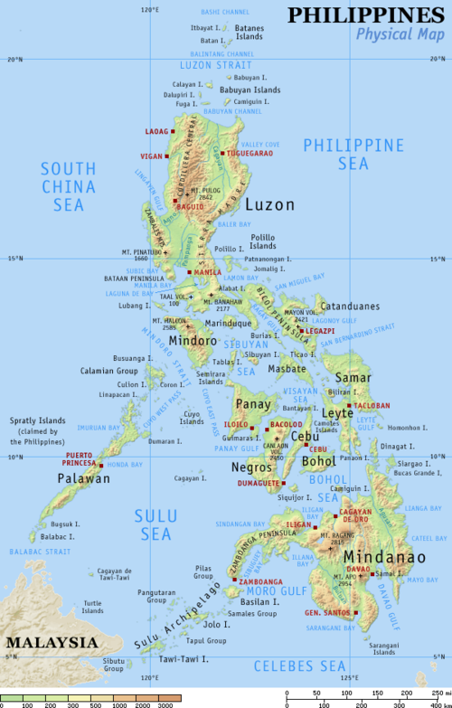
As of 2020, there are 244 protected areas in the Philippines, covering a total area of about 7,760,000 hectares (19,200,000 acres) – 15.4% of the Philippines' total area. (Full article...)
Upolu Island, Samoa This is a list of some protected areas of Samoa which include national parks, reservations, protected nature zones, marine reserves and other areas of significant biodiversity and conservation.
In 1994, Samoa ratified the international and legally binding treaty, the Convention on Biological Diversity to develop national strategies for conservation and sustainable use of biological diversity. In 2010, protected areas in the country cover 5% of land although the government aims to increase protected areas coverage to 15%. (Full article...)
Forests in the state of Himachal Pradesh (northern India) currently cover an area of nearly 37,939 square kilometres (14,648 sq mi), which is about 68.16% of the total land area of the state. The forests were once considered to be the main source of income of the state and most of the original forests were clear felled. The emphasis has shifted, however, from exploitation to conservation. The state government aims to increase forest cover to 50% of the total land area. There have been various projects, including the establishment of protected areas such as National Parks, designed to preserve and expand the forests. (Full article...)
Image 14
China has more than 10,000 protected areas, covering eighteen percent of the country's land. There are many forms of protected areas in China. Based on their relative importance, each type of protected area can be further graded into two to three levels (national, provincial and prefectural/county level). Nevertheless, the highest rank for "pocket nature preserve" (social and mass-based), "no-hunting area", "no-fishing area", "no-logging area", "wild medicinal material resources conservation area", "crop germplasm resources conservation area", "forest tree germplasm resources conservation area" or "source water protection area" is practically restricted to provincial level. The local government at county level is also responsible for the delimitation and declaration of "basic farmland protection area" and "basic grassland".
Many protected areas (PAs) in China have multiple official designations, and the statutory boundaries of these multi-designated PAs may be identical or may vary from one another. For instance, the boundaries of Huangshan NSHA coincide with those of the Huangshan NGP, whereas Fujian province's Wuyi Mountains NNR, NSHA and NFP are adjacent to each other. In Heilongjiang, 27,642.14 hectares out of 115,340.27 hectares of Huzhong NFP are intersected with the experiment zone of Huzhong NNR. (Full article...)
Image 15
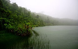
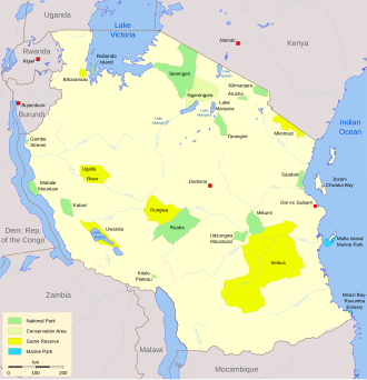
Protected areas in Tanzania (Hifadhi za Mali hai za Tanzania, in Swahili) are extremely varied, ranging from sea habitats over grasslands to the top of the Kilimanjaro, the tallest mountain in Africa. About a third of the country's total area is protected to a certain degree as a national park, game reserve, marine park, forest reserve or the like. 840 protected areas are spread across 7,330 km² of ocean and 361,594 km² of land in Tanzania. The coastal and marine areas are less protected than terrestrial ecosystems, which are given the highest level of protection. Tanzania is one of the world's major biodiversity hotspots thanks to its vast national parks, "the Eastern Arc" mountains, wetlands, coastal forests, marine, and freshwater systems as remarkable reservoirs of plant and animal species. A wide range of endemic species of birds, reptiles, snakes, amphibians, wild coffee variations, and the well-known African violet flower can also be found in Tanzania. (Full article...)
Image 4Only a few of the largest large igneous provinces appear (coloured dark purple) on this geological map, which depicts crustal geologic provinces as seen in seismic refraction data


 Artist's rendition of an oxinated fully-frozen Snowball Earth with no remaining liquid surface water. (from History of Earth)
 Great Pyramids of Giza, Egypt
 Earth's axial tilt causing different angles of seasonal illumination at different orbital positions around the Sun (from Earth)
 A banded iron formation from the 3.15 Ga Moodies Group, Barberton Greenstone Belt, South Africa. Red layers represent the times when oxygen was available; gray layers were formed in anoxic circumstances. (from History of Earth)
 Geologic map of North America, color-coded by age. From most recent to oldest, age is indicated by yellow, green, blue, and red. The reds and pinks indicate rock from the Archean.
 Artist's impression of the enormous collision that probably formed the Moon (from History of Earth)
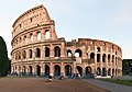 The Colosseum in Rome (from Human history)
 COVID-19 pandemic, 2020 (from Human history)
 Image of the physical world, captured by the Hubble Space Telescope (from World)
 An animation of the changing density of productive vegetation on land (low in brown; heavy in dark green) and phytoplankton at the ocean surface (low in purple; high in yellow) (from Earth)
 Ming dynasty section, Great Wall of China
 Artist's conception of Hadean Eon Earth, when it was much hotter and inhospitable to all forms of life. (from History of Earth)
 An artist's impression of ice age Earth at glacial maximum. (from History of Earth)
 A composite image of artificial light emissions at night on a map of Earth (from Earth)
 Olmec colossal head, now at the Museo de Antropología de Xalapa
 Earth's Western Hemisphere showing topography relative to Earth's center instead of to mean sea level, as in common topographic maps (from Earth)
 An impression of the Archean, the eon after Earth's formation, featuring round stromatolites, which are early oxygen-producing forms of life from billions of years ago. After the Late Heavy Bombardment, Earth's crust had cooled, its water-rich barren surface is marked by continents and volcanoes, with the Moon still orbiting Earth half as far as it is today, appearing 2.8 times larger and producing strong tides. (from Earth)
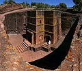 One of the eleven Rock-hewn Churches of Lalibela constructed during the Zagwe dynasty in Ethiopia (from Human history)
 Artist's conception of Devonian flora (from History of Earth)
 Earth's land use for human agriculture in 2019 (from Earth)
 Taj Mahal, Mughal Empire, India
 Pale orange dot, an impression of Early Earth, featuring its tinted orange methane-rich early atmosphere (from Earth)
 A 580 million year old fossil of Spriggina floundensi, an animal from the Ediacaran period. Such life forms could have been ancestors to the many new forms that originated in the Cambrian Explosion. (from History of Earth)
 Dinosaurs were the dominant terrestrial vertebrates throughout most of the Mesozoic (from History of Earth)
 Angkor Wat temple complex, Cambodia, early 12th century
 A view of Earth with its global ocean and cloud cover, which dominate Earth's surface and hydrosphere; at Earth's polar regions, its hydrosphere forms larger areas of ice cover. (from Earth)
 Lithified stromatolites on the shores of Lake Thetis, Western Australia. Archean stromatolites are the first direct fossil traces of life on Earth. (from History of Earth)
 Chennakesava Temple, Belur, India

 Carving of Persian and Median soldiers, Persepolis, Achaemenid Empire, 5th century BCE
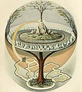 Yggdrasil, an attempt to reconstruct the Norse world tree which connects the heavens, the world, and the underworld. (from World)
 A reconstruction of human history based on fossil data. (from History of Earth)
 Notre-Dame de Paris, France
 Cuneiform inscription, eastern Turkey
 Change in average surface air temperature and drivers for that change. Human activity has caused increased temperatures, with natural forces adding some variability. (from Earth)
 Standing Buddha from Gandhara, 2nd century CE
 The replicator in virtually all known life is deoxyribonucleic acid. DNA is far more complex than the original replicator and its replication systems are highly elaborate. (from History of Earth)
 Obelisk of Axum, Ethiopia
 A reconstruction of Pannotia (550 Ma). (from History of Earth)
 Battle during the 1281 Mongol invasion of Japan
 A depiction of the early Solar System's protoplanetary disk from which Earth and other Solar System bodies were formed (from Earth)
 Benin Bronze head from Nigeria
 The first airplane, the Wright Flyer, flew on 17 December 1903.
 Florence, birthplace of the Italian Renaissance
 A map of heat flow from Earth's interior to the surface of Earth's crust, mostly along the oceanic ridges (from Earth)
 Artist's impression of a Hadean landscape with the relatively newly formed Moon still looming closely over Earth and both bodies sustaining strong volcanism. (from History of Earth)
 Fall of the Berlin Wall, 1989
 Japanese depiction of a Portuguese carrack, a result of globalizing maritime trade
 A schematic view of Earth's magnetosphere with solar wind flowing from left to right (from Earth)
 Tiktaalik, a fish with limb-like fins and a predecessor of tetrapods. Reconstruction from fossils about 375 million years old. (from History of Earth)
 Earth's history with time-spans of the eons to scale. Ma means "million years ago", Ga means "billion years ago". (from History of Earth)
 Graph showing range of estimated partial pressure of atmospheric oxygen through geologic time (from History of Earth)
 13th-century French historiated initial with the three classes of medieval society: those who prayed (the clergy), those who fought (the knights), and those who worked (the peasantry)
 Portrait of Alfraganus in the Compilatio astronomica, 1493. Islamic astronomers began just before the 9th century to collect and translate Indian, Persian and Greek astronomical texts, adding their own astronomy and enabling later, particularly European astronomy to build on. Symbolic for the post-classical period, a period of an increasing trans-regional literary culture, particularly in the sciences, spreading and building on methods of science. (from Human history)
 A computer-generated image mapping the prevalence of artificial satellites and space debris around Earth in geosynchronous and low Earth orbit (from Earth)
 Successive dispersals of Homo erectus (yellow), Homo neanderthalensis (ochre) during Out of Africa I and Homo sapiens (red, Out of Africa II), with the numbers of years since they appeared before present. (from Human history)
 Earth's night-side upper atmosphere appearing from the bottom as bands of afterglow illuminating the troposphere in orange with silhouettes of clouds, and the stratosphere in white and blue. Next the mesosphere (pink area) extends to the orange and faintly green line of the lowest airglow, at about one hundred kilometers at the edge of space and the lower edge of the thermosphere (invisible). Continuing with green and red bands of aurorae stretching over several hundred kilometers. (from Earth)
 Last Moon landing: Apollo 17 (1972)
 Vitruvian Man, c. 1490 by Leonardo da Vinci, epitomizes the advances in art and science seen during the Renaissance. (from History of Earth)
 Satellite time lapse imagery of Earth's rotation showing axis tilt (from Earth)
 Pillar erected by Ashoka, a Mauryan Emperor in India
 Trilobites first appeared during the Cambrian period and were among the most widespread and diverse groups of Paleozoic organisms. (from History of Earth)
 An artist's rendering of a protoplanetary disk (from History of Earth)
 Machu Picchu, Inca Empire, Peru
 Cross-section through a liposome (from History of Earth)
 Chloroplasts in the cells of a moss (from History of Earth)
 European migrations by mostly Germanic peoples, 2nd–6th centuries (from Human history)
 A composite image of Earth, with its different types of surface discernible: Earth's surface dominating Ocean (blue), Africa with lush (green) to dry (brown) land and Earth's polar ice in the form of Antarctic sea ice (grey) covering the Antarctic or Southern Ocean and the Antarctic ice sheet (white) covering Antarctica. (from Earth)
 A view of Earth with different layers of its atmosphere visible: the troposphere with its clouds casting shadows, a band of stratospheric blue sky at the horizon, and a line of green airglow of the lower thermosphere around an altitude of 100 km, at the edge of space (from Earth)
 A pillar at Neolithic Göbekli Tepe
 Pangaea was a supercontinent that existed from about 300 to 180 Ma. The outlines of the modern continents and other landmasses are indicated on this map. (from History of Earth)


.svg)


.png)

.jpeg)


.jpg)


.jpg)


.jpg)


 The world map by Gerardus Mercator (1569), the first map in the well-known Mercator projection
 Time zones of the world
 The Goode homolosine projection is a pseudocylindrical, equal-area, composite map projection used for world maps.
 Only a few of the largest large igneous provinces appear (coloured dark purple) on this geological map, which depicts crustal geologic provinces as seen in seismic refraction data
 United Nations Human Development Index map by country (2016)
 A plate tectonics map with volcano locations indicated with red circles
 1516 map of the world by Martin Waldseemüller
 Index map from the International Map of the World (1:1,000,000 scale)
 Mollweide projection of the world


 Commons
 Wikibooks
 Wikidata
 Wikinews
 Wikiquote
 Wikisource
 Wikispecies
 Wikiversity
 Wikivoyage
 Wiktionary

